LORAN (LOng RAnge Navigation) is a terrestrial navigation system using ground-based transmitters. Hyperbolic LORAN lines of position (LOP) are formed by measuring the difference in reception times of synchronized signals. A LORAN net, or chain, requires a master station, initiating the pulse, and a series of slave stations. In very simplified terms, the master transmits and the slave responds. Charted values of this time delay measurement were placed upon a navigational chart. The measurement observed placed one somewhere along a LOP. That information is of little value without a LOP from a second pair. The point of intersection of the two LOPs is the location of the ship or aircraft receiving the signals. The station configurations thus must provide a geometry that allows such intersection.
This initial LORAN system is known as LORAN A. This ‘Top Secret” project was developed during World War II in response to the need of military ships and aircraft for a precise navigational system. Scientists at the Massachusetts Institute of Technology and the Bell Laboratories, with the support of the War and Navy Departments made theory a reliable reality. The Coast Guard’s involvement began in 1942 when Vice Admiral Waesche, Commandant of the Coast Guard, was asked to recommend an officer to direct the program. Lieutenant Commander Lawrence M. Harding was given the task and brought rapid progress to the project. In mid 1943 the North Atlantic chain became operational. The success in the North Atlantic led to rapid expansion elsewhere.
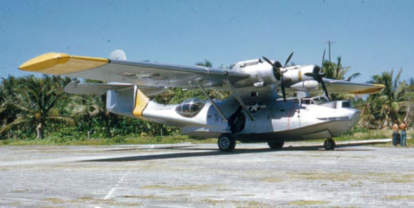
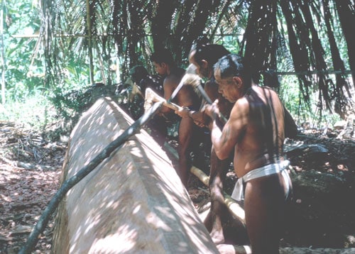
Construction and operation of the North Atlantic chain was a joint endeavor. The site selection, construction, and operation of the LORAN system in the Pacific was an all Coast Guard undertaking. The first group of stations constructed was the Bering Sea chain. Site surveys and calibration support was provided by a Coast Guard PBY-5 number V-189. This aircraft made 96 flights resulting in 354 hours of flying, most of which were conducted under adverse weather conditions. As there were no handling facilities at the three destinations it was necessary to anchor the plane in the open. V-189 continued to provide this type of support throughout the construction of the Pacific chains. When the command unit moved to Guam an additional PBY-5A was obtained as was a PB4Y-2. Construction of the Western Aleutian and Hawaii chains were next. From that point on the other five chains came into being. The Pacific military campaign was the determining factor and construction overlapped. Three construction detachments were utilized.
The importance of LORAN to the war effort can not be overstated. The extent of problems overcome in establishing the individual stations was exceeded only by the magnitude of the task in general. The stations which were erected provided LORAN service for practically the entire Pacific area in which combat operations were performed.
In the post war period LORAN became the primary electronic navigation system for both ships and aircraft. The Coast Guard was given the responsibility of maintaining and operating the vast majority of all LORAN stations. The LORAN chains in the Pacific were realigned and modified to support post war military and commercial requirements. Whenever and wherever support could be obtained from local sources and/or other military installations it was utilized. A number of the stations, however, were constructed on isolated islands or other remote locations.
A large vessel to supply equipment and personnel was needed for construction and logistical support of the Pacific LORAN chain. The USS Colquit
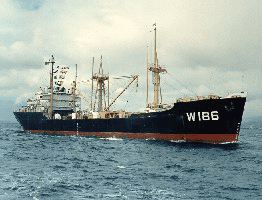
(AK-174) was obtained and converted to Coast Guard requirements. The name was changed to USCGC Kukui (WAK-186). The Kukui carried two LCMs on her decks to ferry men and equipment to shore and also had three bulldozers, several trucks and a few jeeps stashed in her holds. Seven months a year she was underway providing necessary logistic support to members of the Coast Guard LORAN chain throughout the western Pacific. During this time she delivered “everything from toothpicks to antenna poles; from a can of pepper to a “Quonset Hut.” She also carried the complex electronic equipment necessary to set up the LORAN system. The Officers and men not only sailed the ship but they operated bulldozers, landing craft, trucks and jeeps.”
The USCGC Nettle (WAK-169), a former Army FS, was also obtained for LORAN support. She spent the first six years at Kwajalein atoll followed by a year at Guam and then was based out of Sangley Point to support the Philippines Section. At intervals during the years a 180 foot buoy tender was stationed at Guam. At other times, support for the Pacific island stations was provided quarterly by 180 foot buoy tenders based at Hawaii.
Completing the picture was regular aviation support. The isolated stations in Alaska were serviced out of Air Station Kodiak and French Frigate Shoals was supplied initially by the Air Detachment at Kaneohe, Hawaii and continued when the air detachment moved to Barbers Point. In addition to French Frigate shoals the detachment flew an extended logistic flight throughout the Pacific, The logistic flights were WESTPACs and those that flew these flights referred to themselves as “Cosmic Overseas Airways.” In addition there were air detachments established at Sangley Point in the Philippines and at Guam to provide logistic support to isolated LORAN stations.
Coast Guard Air Detachment Sangley Point
In April of 1945 an advance base maintenance organization and construction of a runway was begun to support the continuing war effort. The Naval Air Base Sangley Point was not large, encompassing an area of only 341 acres. Half of which was occupied by its most valuable asset: the 7000 foot runway and its associated air-operations facilities. A small Coast Guard air detachment was established at Sangley Point and over time it increased in size and responsibilities and the Commanding Officer of the Air Detachment would serve a dual function as Commander Philippine Section, responsible for all Coast Guard Forces in the Philippines
LORAN stations were constructed at Naulo Point on the west coast of Luzon, Talampulan in the west central Philippines between the large islands of Mindaro and Palawan, and Tarumpitao on the island of Palawan facing the South China Sea. The stations went operational on 19 July 1945. The Coast Guard was constructing and operating the LORAN stations as part of the Navy and upon transfer back to the Treasury Department on 1 January 1946 retained this responsibility. A one PBY air detachment, under the command of LT Walter Curwen, was established in 1946 for the purpose of aerial support for the LORAN Stations.
With the advent of the Korean War the SAR responsibilities of the Coast Guard were expanded and the Sangley Point operation was augmented with the addition of PBM aircraft. Logistics remained a primary mission and SAR responsibilities increased substantially. One mission of note was the attempted rescue of a P2V crew, on a covert mission, that had been shot down by the Communist Chinese forces. (Note: A detailed narrative of this attempted rescue can be found under the narrative; “1952 – Coast Guard and the Korean War”). Another took place 14 July 1960: – Following the loss of a propeller, which resulted in fuselage damage and an engine fire, a Northwest Airlines DC-7C airliner carrying 58 persons ditched in Philippine waters. During the Coast Guard-coordinated air search, a Coast Guard UF amphibian aircraft sighted four life rafts in the vicinity of the Polillo Islands, landed, and rescued 23 survivors. A U.S. Navy P5M seaplane, meanwhile, rescued 34 others and also recovered the body of the only fatality.
SAR coordination and responsibility rested with the Joint Search and Rescue at Clark AFB. The Air Force had a rescue squadron at Clark but for reasons not completely clear, rarely responded to requests for help from the civilian sector. The Navy limited SAR activities to its own and the Philippine Air Force operated SA-16s but were not overly involved. Though the primary mission of the Coast Guard air detachment was logistics, it always responded. Medivacs from LORSTA, ill and injured Filipinos from remote provinces, searched for overdue boats and aircraft, assisted in relief to disaster areas and helped the Navy search for missing aircraft. SAR decreased in the mid to late 60s.
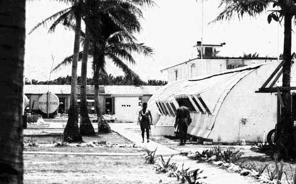
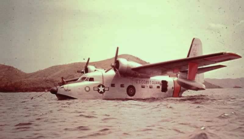
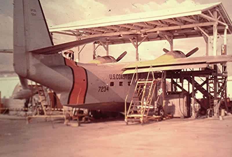
In 1953 two additional LORAN stations became operational and the air detachment was then supporting five LORAN stations. Conditions and resources were primitive by today’s standards. The Coast Guard facilities consisted of a cluster of Quonset huts between the main entrance road and the runway. One Quonset housed the Commanding Officer, XO, the administrative staff, Operations and wardroom. Two smaller Quonsets housed the Avionics Shop and Supply Office. Next came the Spare Parts, Hydraulic, and Aircraft Maintenance Office. Two UF-2G aircraft were maintained in an open nose dock with a corrugated steel roof.
It was a different time and a different environment. The District Headquarters was over 4000 miles away. There was no direct communications with the air detachment. The pilot in most cases was his own everything. Once away from the Manila area, navigation was the LORAN that was being serviced and a low-powered radio beacon at the LORAN station. Visual flight operations were dominant. IMC could be flown but approaches to the destinations had to be fabricated. The destination facilities were marginal. A description of the air operations at the five LORAN stations (LORSTA) is of interest.
LORSTA Batan: The Batane Islands lie 375 miles north of Sangley Point midway between Luzon and Taiwan. The normal morning flight path was north over central Luzon and the return flight normally diverted over the west coast to circumvent the afternoon cumulonimbus build ups. The LORSTA was located on the east side of the main island and the airstrip was on the west side at the capital city of Basco. Basco International Airport, as it was referred to by the Coast Guard aviators who flew in there, was 3000 feet long, unpaved and situated on the side of a mountain running from the sea upslope with approximately a 5 degree grade, Landings were made uphill. Takeoffs were made down hill and normally with a tail wind. JATO was armed and ready in case it was needed for the take off. The trip to the LORSTA was an adventure. Supplies were transported by station vehicle over a narrow twisting one lane road carved out of the side of the mountain.
LORSTA Catanduanes: The island of Catanduanes lies 230 miles east-southeast of Sangley Point. The hilly terrain was unsuitable for an aircraft runway. The LORSTA, known simply as Cat, was situated at the north end of the island with a bay immediately to the west that was adequate for UF/HU-16 water operations as long as the wind and sea conditions were favorable. The aircraft tied up at a buoy and supplies were unloaded by small boat and transported to the boat dock. The bay was semi-exposed to the sea and when the incoming swells made the bay dangerous, landings were made at the south end of the bay. This was separated from the main bay by an island and coral reefs. The aircraft, when using the south bay had to be unloaded at anchor and supplies transported by vehicle to the LORSTA.
LORSTA Naulo Point: Naulo Point LORSTA was in the midst of a coconut plantation on the west Coast of Luzon five miles south of Santa Cruz. Naulo had a grass and dirt 3000 foot airstrip with tall palm trees at each end that the native land owners refused to have cut down. When wet the runway limits were defined on each side by heavy mud and an errant taxi turn would result in the aircraft being bogged down requiring a combination of truck and caribou power to regain the runway. Caribou (water buffalo), the beast of burden in the Philippines, grazed on the runway and had to be herded off prior to landing. Usually this was accomplished by the combined effort of station personnel and the distinct loud propeller noise generated by a UF making a low pass. The impact of a main gear coming in contact with a freshly deposited pile of Carabou dung produced the expected results.
LORSTA Talampulan: Talampulan was one of the islands forming the Calamian group which lie 200 miles southwest of Sangley Point between the large islands of Mindaro and Palawan. The island was a long and narrow jungle covered hill without a landing strip. Landings were made adjacent to the island and heavy ocean swells frequently made it a hazardous operation. It is ironic that regulations required permission of the District Commander, 4000 miles away, for an open-sea landing involving a rescue but that once a week a landing was routinely made in the open sea to deliver supplies to a LORSTA. A slot between two islands to the east offered a more protected landing but required a long wet taxi through the swells to the mooring buoy. With windows and hatches secured for water tightness, this prolonged taxi in the tropics was far from popular. A truly beautiful island, Talampulan was a source of giant clamshells that were sought after by the military personnel throughout the Pacific. Many a clam shell was hauled out.
LORSTA Tarumpitao: Tarumpitao was located on the western shore of Palawan Island, 375 miles southwest of Sangley Point. The station was a collection of Quonset huts and a 3000 foot grass runway set in a clearing in the middle of a dense jungle. The strip had been built by Coast Guard civil engineers and there was little doubt in crewmembers minds that the person who designed it hated aviators. The runway ran into the jungle perpendicular to the shoreline. A tall hill was at the other end. Of further concern was the narrow clearance between the runway and the trees and the prevailing wind was across the runway at a ninety degree angle. During the rainy season the runway was covered with standing water. Braking action was nil and reverse thrust was used to stop the airplane. The native population, unlike at the other LORSTAs, were Morros and were Muslim. There was friction between the Morros and Christians but for some reason that did not apply to the Coast Guardsmen. A discarded Quonset had been donated by station personnel for use as a school house. There was a standing invitation to the locals to come on board the station and watch the movies. The invitation was eagerly accepted.
The entire Coast Guard Philippine Section operation was turned over to the Philippine Government in 1971 and the Coast Guard air station was closed.
Coast Guard Air Detachment Guam
In 1946, after World War II, all coast Guard activities in the western Pacific area were consolidated under a command called the Western Pacific Section. In 1947 a Coast Guard air detachment consisting of one PBY-6A and crew was established at the Naval Air Station, Agana, Guam to provide aerial logistics support for LORAN stations in the southern Marianas and Western Caroline Islands. In 1953 the Western Pacific Section became the Marianas Section located at Cabras Island, Guam. The LORAN stations supported by the Marianas Section were Saipan, Cocos Island, Ulithi, and Anguar in the Palauan Islands. The Moratai chain had been discontinued at the end of World War II and the Palau LORAN station was moved from Peliliu to the previous monitor station at Anguar. Anguar was then paired with Ulithi. The LORAN stations at Saipan, Ulithi and Anguar were serviced by the air detachment. Cocos Island at the southern end of Guam was serviced directly by the Marianas Section.
By the mid 50’s the PBY had been replaced by a UF (Grumman Albatross amphibian). The air detachment consisted of several Quonset huts adjacent to the runway used for administration and maintenance support. A section of a large Quonset, open at both ends, was used as a nose hangar for maintenance. It was wide enough for the wings to be under roof but the tail protruded into the open. Spare parts, if not in stock, were not readily available. It was a long way to the supply base in Elizabeth City. In some cases parts could be obtained from the Coast Guard Air Detachment at Barbers Point and some could be borrowed from naval sources at Guam, but quite often parts were rebuilt or repaired by the station’s maintenance personnel. The unit’s maintenance personnel were, or soon became, quite talented.
The primary mission of the air detachment was aerial supply of the Marianas section LORAN stations. The LORAN station at Saipan received support via facilities on the Island and the aerial supply by detachment aircraft was Coast Guard specific in nature. This was transportation of Section personnel, transfers of personnel in and out, and light maintenance equipment and operational repair parts. The sequence of flight would depend upon need. The LORAN stations at Ulithi and Anguar were scheduled weekly. These stations were located in the region known as Micronesia encompassing an area of 3,000,000 square miles of the tropical Western Pacific Ocean. Most of the islands were quite small, the total land area being only 700 square miles.
The Ulithi atoll, location of LORSTA Ulithi, between Guam in the Marianas and the Western Carolines, is 350 miles southwest of Guam with nothing 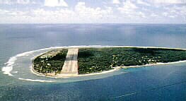 but ocean in between. The atoll is composed of small islets that have a total land area of 1.75 square miles. The huge 209 square mile lagoon is the worlds fourth largest. The Island was isolated and the population was indigenous with their own culture but after World War II a Trust Territory was established providing intensive education and much of the original culture has been eroded over the years. The original LORAN station was built on Pontangeras Island. A 3300 foot paved landing strip had been built on Falalop Island during World War II. The runway extended from ocean edge to ocean edge. The aircraft would arrive from Guam and the LORAN station outboard skiff would make the 12 mile runs across the lagoon and pick up the supplies. The skiff was soon replaced by a DUCK amphibious vehicle which was in turn replaced by a LCM. The LORAN station was moved to Falalop Island in 1953 at a location easily accessible to the air strip.
The Coast Guard personnel got along very well with the Ulithians and twice a year, Christmas and the Fourth of July, people from all the inhabited islands were invited to the Loran station on Falalop to celebrate. Activities were athletic games, native dancing and a feast. Movies were always open and well attended by the people of Falalop. Inhabitants of the other islands would periodically come over for that purpose also. When the Yap LORAN C station went on the air in 1964 the Ulithi Loran A station was decommissioned and the LORAN A function was moved to Yap Island.
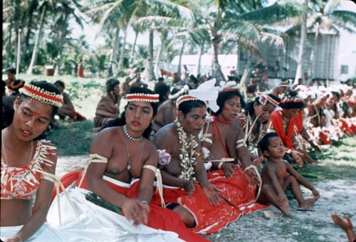
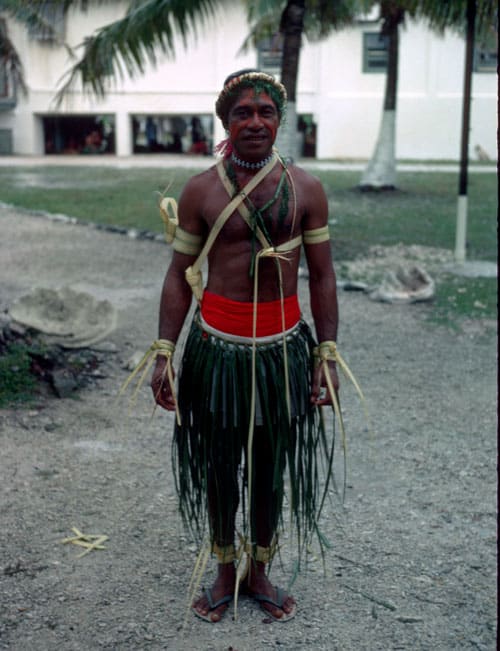
Above photo –female dancers during a celebration. Photo on right – Ulithi male in dancing costume
Anguar is an island in the Palauan Chain (Western Carolines) with an area of three square miles and a population that varied around 200. It lies 4000 miles west/southwest of the Coast Guard District Headquarters in Hawaii, 826 miles southwest of Guam and 620 miles east of the Philippine Islands. The population of Palau, primarily Melanesian, had experienced outside influence by both Japanese and German administrations which introduced coconut planting and phosphate mining to the islands. Anguar as well as the adjacent island of Peliliu saw extensive military battles during World War II. When the islands were taken from the Japanese a 7000 foot runway was built on Anguar to accommodate B-24 bombers in the campaign against the Philippine Islands. This runway was maintained and used to supply the LORAN station located a short distance away.
The trip to Anguar usually included an over-night (RON) stay either at the station or at Koror 46 miles to the northwest. Koror was a water operation and had a seaplane ramp which was used to park the aircraft. Trust Territory and Coast Guard personnel were flown in and out as requested. The distance from Guam, size of the cargo loads, and the fact that the route of flight passed through the Inter-tropical Convergence Zone could at times make the round trip “fuel critical.” As a result aviation fuel, in 55 gallon drums, was transported to Anguar quarterly. Fuel would be put into the float tanks and transferred to the mains. Fuel in 55 gallon drums was also stored at the Ulithi station in case it was needed.
The establishment of the United Nations Trust Territory of the Pacific Islands (TTPI) in 1947 affected the Guam operation. The United States was named as the administering authority. The area stretched from the Marshall Islands in the east to the Carolines in the west and included the Marianas (excluding Guam). The headquarters of the Trust Territory was located in Saipan. In the early years transportation was limited and requests for assistance were frequently made of the Coast Guard. A number of islands within the Trust Territory had runways built during WWII but a number did not. The Coast Guard had an amphibian that could utilize the runways and was capable of water operations where runways did not exist. As a result the air detachment would make flights to Majuro, Ponape, Truck, Yap, Koror, and other destinations when requested. The Trust Territory established its own air transportation service and by 1960 had three SA-16 (UF) aircraft that were flown on contract by Pan American World Airways. The Coast Guard continued to supplement the operation but normally in emergent situations. As development continued airport facilities were constructed where needed and jet service was initiated.
The initial priority within the Trust Territory was education followed by economic development. Initial schooling was provided by missionaries and this was followed by the establishment of elementary schools. If a young person wished to go to High School or Junior College they had to go to Guam. In order to facilitate this, personnel on Guam were asked to “sponsor” these young people which meant to take them into ones home not as a servant but rather as part of the family. A number of the people attached to the air detachment sponsored these young people during this period. It is of note that Kuniwo Nakamura, sponsored by Merrill and Mona Wood, Coast Guard air detachment, 1962-1964, went on to the junior college at Guam and from there to the University of Hawaii. Kuniwo became the third President of the Republic of Palau in 1993 and served two four year terms. In 1965 the movement toward autonomy began. In 1975 the Northern Marianas voted to become a commonwealth of the United States. By 1986 all remaining island groups were either Federations or Republics and the Trust Territory agreements were no longer in effect.
SAR activities were limited. They consisted primarily of medical evacuations both Coast Guard and Trust Territory. The loss of aircraft or ships at sea was infrequent. When they did occur, the Coast Guard was called upon to assist. The on-scene search time of the UF was of definite value to the search operation.
In 1962 a Typhoon devastated the Island destroying the facilities and for a two year period operations were conducted out of temporary structures until the new hangar and Marianas Section building was completed at Agana. In 1964 a Loran C station was constructed on Yap Island which is an Island about 106 miles almost due west of Ulithi. An airport was built at the same time. A LORAN A station was co-established, replacing Ulithi, and continued to operate until the LORAN A chain was disestablished in 1978. The UF aircraft was replaced by two C-123 aircraft capable of hauling larger and more bulky loads. In 1966 one of the Guam C-123s, with crew, was deployed to assist in the construction of LORAN stations in Thailand and Vietnam. This was a Top–Secret project requested by the US Air Force. It is detailed in a narrative in the 1957-1975 section of the History Timeline.
The Coast Guard air detachment, by then called an air station, was disestablished in 1972.