On February 10, 1807 Congress authorized an accurate survey to be taken of the coasts and harbors of the United States. The Survey of the Coast was established to provide this service. The name of this organization evolved into the United States Coast and Geodetic Survey. (C&GS)
Each chart was built from two types of surveys. The first was a hydrographic survey, which mapped the depths of the waters and depicted hazards. The other was a topographic survey which mapped the land, including the shoreline, natural features, and elevations above the sea. The first shoreline map drawn by the Coast Survey covered the shore of Great South Bay on Long Island, New York. The Coast Survey relied on a method called plane table surveying. This was the primary method of mapping for the next 80 years.
By the late 1800s photography was recognized as a useful tool in mapping. The C&GS first used a surveying camera with a plane table for mapping the international boundary between Alaska and Canada in 1894. The use of ground photos continued and in the early part of the next century, aerial cameras were developed with multiple lenses, producing a much wider field of view. The rapid development of the aircraft during World War I provided an effective platform by which the cameras could be used for mapping. The C&GS started work with the US Army Air Service using Air Service aircraft and crews to provide photographs to compile coastal topography. Between 1920 and 1928, a series of aerial surveys were made of the New Jersey coastline, the Florida coastline, and the Mississippi River delta. Topography from aerial photographs not only proved to be more detailed and accurate than the plane table but could be done for about one-third of the cost.
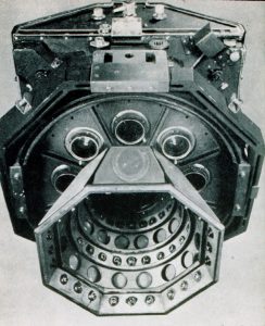
Multiple photos were taken but because of the narrow fields of view it required many photos to cover a moderately sized area. Area could be increased by taking the photos at higher altitudes but detail was lost. A multi-lens, high resolution camera could take several photos looking downward at different angles simultaneously. These could be combined into a single quality composite image that covered a much larger area of ground. In 1935, the C&GS had a precision nine-lens camera built. The camera was large weighing 750 pounds when fully equipped and the roll of film it used was 200 feet long and 23 inches wide.
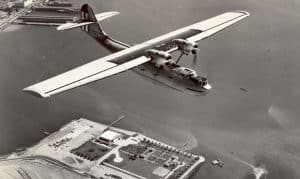
A satisfactory aircraft was needed as a platform for the camera. The C&GS, except for a short period of time, had been and was under the jurisdiction of the Treasury Department. It was thus logical for the Treasury Department to turn to the Coast Guard to provide the needed aircraft and crew. The Coast Guard purchased PBY, Bureau Number 2290 from the Navy on 18 October, 1940 and renumbered it V-189. The aircraft was purchased for the specific purpose of aerial mapping in conjunction with the C&GS. The aircraft was configured to include a mount to accommodate the nine-lens camera in the “waist gunners” position. The first assigned crew under the command of LCDR George Bowerman included Captain Kay, a C&GS officer. This crew and aircraft conducted the first aerial survey assignment utilizing a Norden Bomb-sight in the aerial mapping process.
The marine and aeronautical charts of Alaska were less than satisfactory; especially along the Alaskan Peninsula and the Aleutian Islands. Upgrading the existing charts became the immediate tasks for the summer months of 1941. PBY V-189 operated from Kodiak Island and Dutch Harbor, Unalaska Island. Inadequate facilities and poor weather, especially at Dutch Harbor, effected both operations and results.
In August V-189 returned to its home base at San Francisco and was immediately given a new assignment. This mission included aerial photo-mapping of the coastal areas of the Gulf of Mexico and the east coast of the United States from the southern tip of Florida to Maine. Shortly after V-189 returned to San Francisco the Japanese attacked Pearl Harbor and the United States was at war. On December 15, 1941, PBY-189 and crew were transferred to Navy Patrol Squadron 44 (VP-44) at Naval Air Station, Alameda California. In May of 1942, V-189 was transferred back to the Coast Guard to carry out vitally needed photo mapping of the Alaska area of operations. The crew and aircraft proceeded to Sitka, Alaska and commenced a mapping of southeast Alaska. From there they proceeded to Kodiak to obtain detailed photos of specific areas and then on to Unga of the Shumagin Islands. Weather was much more favorable than on the first mission and photo mapping pressed westward until encountering Japanese patrols. Some of the operations required flight altitudes as high as 20,000 feet. In September of 1942 V-189 returned to San Francisco. V-189 was then used in the construction of the LORAN chains in Alaska and throughout the Pacific.
Mapping operations continued and were carried out with a second aircraft obtained by the Coast Guard for this purpose. The camera was transferred to PBY-5A Bureau Number 08055. This was an amphibious aircraft and the availability of landing gear made it more versatile in the extreme environment of Alaska. Unfortunately this aircraft crashed on Mount Moffet, Adak, Alaska, on 18 July 1943. Only two crewmembers survived. The nine lens camera, the only one in existence, was severely damaged. It was recovered and rebuilt and then installed in a specially adapted Coast Guard PB-1G aircraft after World War II. During the war a Coast Guard JRB aircraft was specially equipped to assist in C&GS photo-mapping operations.
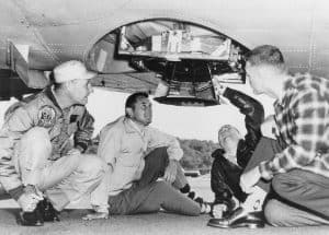
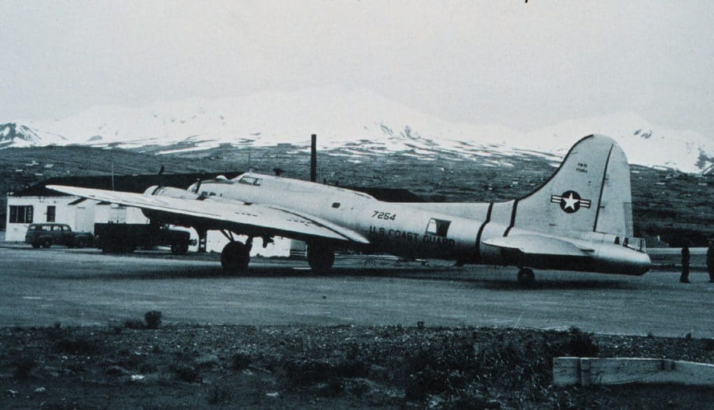
The PB-1G selected was transferred to the Coast Guard in 1946 and given the CGNR 7254. It had only 52 and ½ hours on the airframe at the time of acceptance making it for all practical purposes a new aircraft. The bomb bays were sealed and oxygen tanks installed. The aircraft construction readily accepted the nine-lens camera under the fuselage. The Norden Bomb-sight was retained. The capability of the aircraft was such that most of the photo-mapping missions were flown between 20,000 and 30,000 feet. At 22,000 feet the camera could photograph 315 square miles of terrain with one click. For twelve years the 7254 flew mapping missions ranging from Alaska to Puerto Rico. During these years the aircraft, home based at the Elizabeth City air station, flew just under 6000 hours covering more than one and a half million miles.
As the years passed the nostalgia generated by the aircraft continued to increase. Coast Guard crews stated that in cases when they would transit or base out of an Air Force installation, where the commanding officer had flown B-17s during World War II, the reception was especially warm. The 7254 was the last PB-1G/B-17 operated by the United States military services. The last flight was made on 14 October 1959.
The Coast Guard operated 15 R5D-3/4 (C54) aircraft, nine of which had been acquired from the USN and six from the USAF. The first six R5D-3’s were acquired from the USN in 1945. The remaining nine were acquired after 1949. In addition to logistical and transport duties, these aircraft were used for search and rescue (SAR), service with the International Ice Patrol. Specific missions such as electronic testing and photographic mapping were assigned to specially equipped aircraft. The R5D CGNR 2486 had been a RC54V aircraft, V denoting photo reconnaissance, and in 1960 the nine-lens C&GD camera was installed. This became the photo-mapping aircraft for the next four years.
In 1964, after 25 years of working together the Coast Guard and the C&GS service ended their arrangement for aircraft services. In 1965, the C&GS was reorganized along with the Weather Service and some other agencies to form the Environmental Sciences Service Administration (ESSA) in the Department of Commerce. Under ESSA the C&GS leased aircraft and in 1969 acquired a surplus deHavilland Buffalo aircraft. Converted to aerial photography, this aircraft served for ten years.
The ESSA was reorganized in 1970 and became the National Oceanic and Atmospheric Administration (NOAA)