The American political environment, territorial claims of several governments, and deteriorating Soviet-American relations created the opportunity for the United States Navy to heavily expand polar operations. The purpose was both strategic and exploratory. It was deemed to be in America’s best interest to expose and prepare men, ships, and equipment to the harshness of Polar Regions as rapidly and efficiently as possible.
During the fall and winter of 1945-1946, an operation to determine the feasibility of a large naval force in polar conditions was conducted. This was followed in the summer of 1946 by Operation NANOOK, under the command of Captain Richard Cruzen. The second phase of the plan called for the establishment of weather observation and reporting stations in the Canadian Arctic and Greenland. But there was more to the operation. The task force was made up of two Navy AK transports modified for sub-zero operations, fully equipped to construct the stations. In addition, the Seaplane tender USS Norton Sound, with two PBM seaplanes, was part of the Task force as was the submarine Atule which conducted tests and carried out operations under the ice in Baffin Bay and to the north. The wooden hulled net tender Whitewood was used as a survey ship. The Coast Guard ice breaker Northwind joined the group north of the artic circle providing escort and navigation through the ice fields. The Northwind had on board an HNS helicopter piloted by Coast Guard Aviation Pilot 1/c John Olsen. This was a precursor of things to come in polar operations.
Admiral Richard E Byrd USN (Ret) was a Naval Aviator and in addition to flying over the North Pole, he had conducted three expeditions to Antarctica between 1928 and 1941. During World War II, Byrd, a close personal friend of President Roosevelt, had been appointed a special assistant to Admiral Ernest J. King, Chief of Naval Operations. With the war over, it was Admiral Byrd who persuaded Secretary of the Navy James Forrestal and the Chief of Naval Operations, Chester Nimitz, into launching a huge naval expedition to the Antarctic. Congress approved and provided funds. It was emphasized that the expedition would be a Navy operation with naval interests predominating over scientific studies.
During the summer of 1946 orders addressed to commanders in chief of the Atlantic and Pacific Fleets established the Antarctic Developments Project. It was code named Operation HIGH JUMP. High Jump was carried out during the 1946-1947 Antarctic summer. Instructions were for twelve ships and several thousand men to make their way to the Antarctic rim to:
- Train personnel and test material in the frigid zones;
- Consolidate and extend American sovereignty over the largest practical area of the Antarctic continent;
- Determine the feasibility of establishing and maintaining bases in the Antarctic and to investigate possible base sites;
- (Develop techniques for establishing and maintaining air bases on the ice, with particular attention to the later applicability of such techniques to operations in interior Greenland, where, it was claimed, physical and climatic conditions resembled those in Antarctica;
- Amplify existing knowledge of hydrographic, geographic, meteorological, geological, and electromagnetic conditions in the area.
It was planned to construct an American base on the Ross Ice Shelf near Little America III, home to Richard Byrd’s 1939-41 expedition. When the base, known as Little America IV, was established, a systematic outward radial expansion of air exploration would be conducted by ship-based planes operating along the Antarctic coastline and by land-based airplanes departing from the base camp. Although not specifically stated in the August 26, 1946 orders, a central objective of the project was the aerial mapping of as much of Antarctica as possible, particularly the coastline
RADM R.H. Cruzen was the Task Force Commander and RADM Richard Byrd, who based his operations at Little America IV, headed up the scientific and technical work of the expedition. In order to expose as many men as possible to polar conditions, none of the ships used in Operation NANOOK, with the exception of the Northwind, were sent south. Instead, the commanders of the Pacific and Atlantic Fleets each designated six ships for the expedition. A conference was held in early autumn to prepare charts and navigational aids. Cruzen, Byrd, and others gave serious thought to the goals and priorities of the expedition and agreed that the primary objective should be the complete mapping of the Antarctic coastline and as much of the interior as possible.
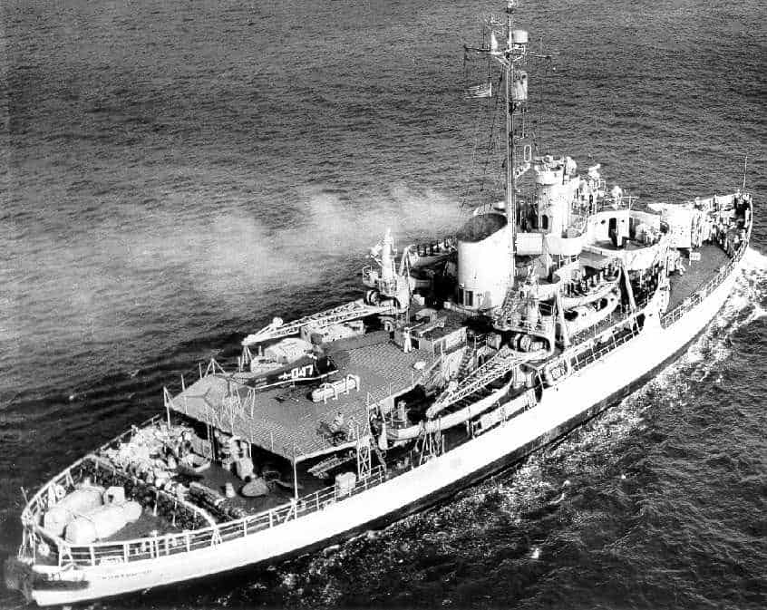
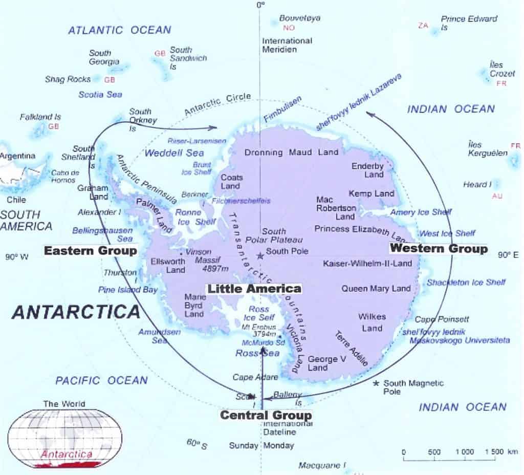
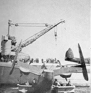
The expedition was divided into three groups with the central group, led by the USCGC Northwind thrusting into the ice pack of the Ross Sea. Following close behind were the cargo ships USS Yancey and USS Merrick, the submarine USS Sennet, and the flagship USS Mount Olympus. The Navy’s newly launched icebreaker USS Burton Island was undergoing sea trials and did not arrive until late in the final stages of the operation. On either side of the center group was the Eastern and Western Groups. The Eastern Group, built around the seaplane tender USS Pine Island, rendezvoused at Peter Island and moved towards zero degrees longitude. With the Pine Island where the oiler USS Canisto and the destroyer USS Brownson. The Western Group was built around the seaplane tender USS Currituck. With the Currituck were the oiler USS Cacapon and the Destroyer USS Henderson. The Rendezvous point was the Balleny Islands. Each of the seaplane tenders carried three PBM flying boats. The aircraft carrier USS Philippine Sea was used to deliver six specially equipped R4D aircraft for operation out of Little America IV. The Navy purchased three additional HO3S helicopters for the expedition. One was assigned to the USS Philippine Sea and one to each of the seaplane tenders. A fourth HO3S was carried by the USS Burton Island when she joined the Task Group. Two of the HO3Ss were lost. The USCGC Northwind had a J2F-6 amphibian and an HNS-1 helicopter aboard. The helicopter was aboard at the insistence of the commanding officer, Captain Charles W. Thomas. An HNS-1 had been used during Operation NANOOK, in Arctic waters during the past summer and proved to be of significant value to the operation.
The Northwind departed Norfolk, Virginia on December 2, 1946, bound for the Antarctic via the Panama Canal. The J2F made reconnaissance, liaison and supply flights and acted as a standby rescue and medical evacuation aircraft. The helicopter served admirably in finding leads in the ice for the Northwind.
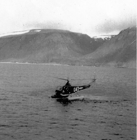
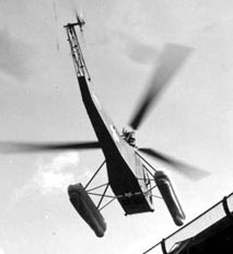
The Central Group rendezvoused at Scott Island on December 30, 1946, to follow the Northwind through the pack ice into the open waters of the Ross Sea. RADM Cruzen shifted his flag to the Northwind and the convoy, strung out at 100-yard intervals, headed south along the 180-degree meridian. The HNS-1 operated from a specially built platform and was put into immediate use. The Helicopter flew at 600 feet and surveyed the packed ice that barred entry into the Ross Sea. The three pilots aboard the Northwind were Lt. Jim Cornish, Lt. Dave Gershowitz and Aviation Pilot John Olsen. Lt. Gershowitz stated that both Captain Thomas and Admiral Cruzen, who had changed his flag to the Northwind for the trip through the ice pack, went up on every suitable occasion. Gershowitz wrote that due to the low temperatures the air was very dense and greatly increasing helicopter performance. Aircraft corrosion was not a problem but on one occasion the airspeed indicator froze up. Only 60 minutes of preparation for the purpose of pre-heating the engine and removing ice from the rotor blades was necessary
The sun shone 24 hours a day, a condition that made possible the maximum utilization of the helicopter. As the Northwind began to buck the ice pack the helicopter would fly slowly in front of the caravan scouting the vast area ahead looking for ice leads; – the cracks in the pack which made penetration by the convoy possible. When it became apparent that the ice presented a serious danger to the USS Sennet, the Northwind towed and escorted the submarine back to Scott Island and then rejoined her convoy. It took 18 days to wedge through 600 miles of ice and reach the Ross Sea and proceed to the Bay of Whales. The Central Group reached the Bay of Whales on 15 January, with the Northwind breaking out a harbor for them. RADM Cruzen shifted his flag back to the USS Mount Olympus. Vital time had been gained because the Northwind did not have to slow up when the helicopter was searching for leads. Three operational flights were made by the J2F en route but open water was needed for takeoff and landings and valuable time was lost in getting it over the side. The Duck had a greater range but the slow moving ships created a situation where range was not too important.
Upon arrival, construction began immediately. An assortment of vehicles including tractors, jeeps, weasels, bulldozers and other tracked equipment were used in the undertaking. By the beginning of February, Little America IV consisted of many tents, one Quonset hut, three compacted snow runways and a short airstrip made of steel matting. Once at Little America, the mission broadened for both Northwind aircraft to include photo flights and the transfer of personnel. Special floats were made for support in the snow. Jim Cornish was the first aviator to fly a helicopter in and out of Little America. A total of 128 flights were made in the helicopter during Operation HIGH JUMP. Gershowitz wrote that the Emperor penguins stared at them in ill-concealed astonishment whenever they took off and landed. They named the HNS-1 the “Flying Penguin.”
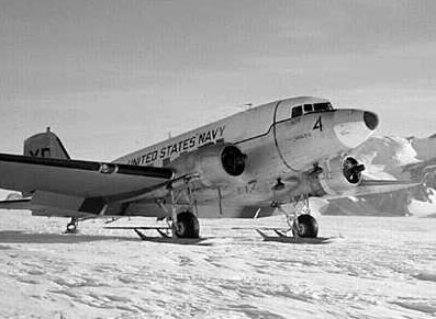
On 25, January the aircraft carrier USS Philippine Sea rendezvoused with the Northwind, the oiler USS Cacapon, the destroyer USS Brownson and the submarine USS Sennet near Scott Island. The Philippine Sea had six R4D which were placed on the flight deck and 57 tons of construction material that was transferred to the Northwind by high wire for delivery to Little America. After transfer, the Northwind proceeded to point midway between the Philippine Sea and Little America and acted as a rescue and weather station for the R4D Flights through the 30th. Two aircraft departed for the flight to Little America on 29 January and the remaining four departed the following day. JATO assisted takeoffs were required. Upon arrival of the R-4Ds in Little America Northwind proceeded to the Bay of Whales and off-loaded cargo. The carrier’s objective being completed she departed for her home port. The USS Sennet had served as weather and radio relay station after being escorted out of the ice pack and after acting as stand-by rescue vessel for the R4D flights from the Philippine Sea to Little America proceeded to Wellington New Zealand completing her involvement in Operation HIGH JUMP.
The Western Group reached the edge of the ice pack northeast of the Balleny Islands on 24 December. The USS Henderson and the USS Cacapon
fanned out to act as weather stations and flight operations from the USS Currituck began. A few flights were attempted but fog plagued them until 1 January. The fog lifted and the first mapping flight of about seven hours was flown along the Oates Coast and was completely successful. The weather held and utilizing ice bays in the ice pack for wind protection, flights were made on the 2nd, 4th, 5th, and 6th over the continent and their staging area. Operations were eminently successful and with the first assignment completed the Currituck proceeded past the Adelie Coast on to Wilkes Land along the Sabrina, Knox, and Queen Mary Coasts. No flights were possible until January 22 due to a huge northerly swell. Over the next week, long and successful photomapping missions progressed to the west.
On February 1 a PBM piloted by LCDR David Bunger USN lifted off and headed south for the continent. Reaching the Coast Line, Bunger flew west and began photomapping. Suddenly in the barren white below, there appeared a blue and green lake among brown barren hills. The PBM landed but was without technical tools to examine the water but did collect a sample of water in a bottle. It turned out to be brackish indicating that the “lake” was actually an open arm of the sea. The weather turned typically Antarctic limiting flights to only three days for the rest of February. On March 1 the final flights were made in the vicinity of the Ingrid Christensen Coast. On March 3 the USS Cacapon, the USS Henderson, and the USS Currituck sailed for Sydney, Australia.
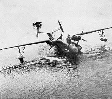
Operations of the Eastern Group commenced in the vicinity of Peter Island north of the Bellingshausen Sea on 23 December. Fog, Blizzards, heavy swells and frequent snow squalls plagued the USS Pine Island operations. The weather suddenly cleared in the afternoon of 29 December and a PBM was lifted over the side and fueled without difficulty and departed. When weather proved to be satisfactory over the continent a second PBM was launched followed later by the third. The first aircraft, after three hours of flight at 400 feet above the ice climbed to 1000 ft. It began picking up ice in fine driving snow. The plane suddenly entered an “ice blink”; -in which streams of sunshine trapped beneath the clouds and bounced off the snow in a million directions. To make matters worse the fine snow had obscured the ground below. The aircraft was gently banked to reverse course and leave the area when a crunching shock reverberated along the hull. The plane had obviously grazed something. Full power was applied and an immediate climb was initiated. The aircraft began to rise and then blew up. Inclement weather precluded search flights until 11 January. The survivors were located and supplies were dropped. It was ascertained that they could travel to open water ten miles to the north. A second PBM landed on the open water and transported a sled and supplies to shore and proceeded towards the survivors. They were located and the entire party returned to the aircraft and flew back to the Pine Island and from there back to the United States. Three crewmembers died in the crash, six survived but one of the survivors, LeBlanc, legs had to be amputated.
Further photo mapping flights from the USS Pine Island were conducted covering the Getz Ice Shelf to the vicinity of Thurston Island. In early February the ship moved to the northeast of Charcot Island and flights were made to Charcot and Alexandria Islands and Marguerite Bay. By March 4, the Eastern Group had departed Antarctic waters.
Arguably the greatest achievement of Operation HIGH JUMP was the acquisition of approximately 70,000 aerial photographs of the Antarctic Coast and selected inland areas. The Navy had proved its capability of operating in the harsh polar climates. From the operational stand point, the use of and need for helicopters in polar operations was firmly established.
The following account of operations was written by Captain Charles W. Thomas, Commanding Officer of the USCGC Northwind.
“Facing the worst pack in Antarctic history, the central Group began its penetration of the ice at approximately the intersection of the Arctic Circle and the 180th meridian on a generally southerly course. Since the Northwind was in the van, Rear Admiral R.H. Crusen, the Task Force Commander, shifted his flag to the icebreaker.
In a well organized ice convoy, the commander needs to know what his ships will encounter within the next day. The skipper of the icebreaker is interested in the picture within the next hour or two and the officer of the deck, within the range of his own range of visibility. Of these, the intermediate situation is the most important, because conditions may change with amazing rapidity. Moreover in Operation HIGH JUMP, the Admiral had no means of making a long range reconnaissance. Hence helicopter reconnaissance within a radius of twenty five miles was essential.
The Central Group began working its way through the pack on 31 December 1946. It reached its destination – the Bay of Whales – on 17 January, 1947. Battering a track through 650 miles of ice in eighteen days would not have been possible without helicopter reconnaissance. I have no doubt that the Central Group would have reached its destination. After all, late February is optimal as far as sea ice is concerned. But for shore based operations, the weather has begun to deteriorate before this time.
Had the Task Group penetrated the pack without “eyes” it would have arrived too late in the season to establish a base; then conduct an aerophotographic exploration of a hidden continent. In other words, the Central Group would have been obliged to turn about and get out of the pack before being able to erect Little America No. 4.
A word about the Sennet: About mid-way through the pack, it became obvious to everyone she would never make it. She had to be towed out of the pack- and by the Northwind. Here again the icebreaker’s helicopter proved its indispensability. The submarine had to be towed to safety in the shortest possible time. Otherwise, the other ships of the group were in immediate danger of being crushed. Indeed, the two cargo ships, helpless in absence of the Northwind, were badly holed and would likely have been sunk, but for the timely return of the icebreaker.
This proven success of our helicopter impelled me to send the following message to the Commandant, U.S. Coast Guard: HELICOPTER BEST PIECE OF EQUIPMENT EVER CARRIED IN ICE VESSELS. I might add parenthetically that one of the motivating factors was Headquarters resistance to my efforts to obtain one for the Eastwind more than a year earlier.”
Coast Guard Headquarters did not respond to this recommendation largely due to budget considerations and the ambivalent attitude toward the helicopter. The following year Captain Thomas took the Northwind on the re-established Bering Sea Patrol. He requested a helicopter but it was not provided. In 1948 a HO3S-1G was assigned to the Mackinaw during ice breaking operations. By the early 1950s Bell HTL helicopters operated from the Coast Guard Cutter Storis and other cutters equipped to carry helicopters when serving in Alaskan waters. The Navy, recognizing the potential, placed helicopters and crews aboard icebreakers engaged in subsequent polar operations including those Coast Guard icebreakers assigned to the operation. It was not until 1966 when the Coast Guard began operating both Coast Guard and former Navy icebreakers that Coast Guard helicopters and Coast Guard aircrews were placed on board.