By John Moseley, CGAA Historian
LORAN (LOng RAnge Navigation) is a terrestrial navigation system using ground-based transmitters. Hyperbolic LORAN lines of position (LOP) are formed by measuring the difference in reception times of synchronized signals. A LORAN net, or chain, requires a master station, initiating the pulse, and a series of slave stations. In very simplified terms, the master transmits and the slave responds. Charted values of this time delay measurement were placed upon a navigational chart. The measurement observed placed one somewhere along a LOP. That information is of little value without a LOP from a second pair. The point of intersection of the two LOPs is the location of the ship or aircraft receiving the signals. The station configurations thus must provide a geometry that allows such intersection.
LORAN was a ‘Top Secret” project, directed by the Coast Guard during World War II, in response to the need of military ships and aircraft for a precise navigational system. The importance of LORAN to the war effort cannot be overstated. In the post war period LORAN became the primary electronic navigation system. The Coast Guard was given the responsibility of maintaining and operating the vast majority of all LORAN stations. Whenever and wherever support could be obtained from local sources and/or other military installations it was utilized. A number of the stations, however, were constructed on isolated islands or other remote locations. Coast Guard Aviation acquired another mission – LORAN Station logistics support.
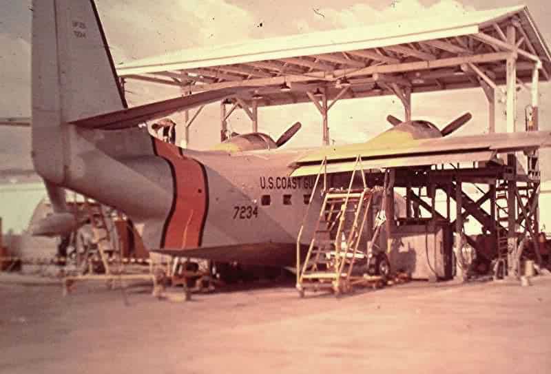
Fifty three hundred miles west of Hawaii, in the Philippine Islands, a small Coast Guard air detachment was established at Naval Air Station Sangley Point. The Mission — provide logistics support to LORAN stations at Naulo Point, Talampulan, Tarumpitao, Batan and Catanduanes. Conditions and resources were primitive by today’s standards. The Coast Guard facilities consisted of a cluster of Quonset huts between the main entrance road and the runway. One Quonset housed the Commanding Officer, XO, the Administrative Staff, Operations and Wardroom. Two smaller Quonsets housed the Avionics Shop and Supply Office. Next came the Spare Parts, Hydraulic, and Aircraft Maintenance Office. Two UF-2G Grumman Albatross aircraft were maintained in an open nose dock with a corrugated steel roof.
The pilot in most cases was his own everything. Once away from the Manila area, navigation was the LORAN that was being serviced and a low-powered radio beacon at the LORAN station. Visual flight operations were dominant. Local knowledge was imperative. Instrument flight was flown but approaches to the destinations had to be fabricated by the pilots. The destination facilities were marginal. A description of the air operations at the five LORAN stations (LORSTA) will provide a feeling for the operation.
LORSTA Batan: The Batane Islands are 375 miles north of Sangley Point midway between Luzon and Taiwan. The normal morning flight path was north over central Luzon and the return flight normally diverted over the west coast to circumvent the afternoon cumulonimbus build ups. The LORSTA was located on the east side of the main island and the airstrip was on the west side at the capital city of Basco. Basco International Airport, as it was referred to by the Coast Guard aviators who flew in there, was 3000 feet long, unpaved and situated on the side of a mountain running from the sea upslope with approximately a 5 degree grade, Landings were made uphill. Takeoffs were made downhill and normally with a tail wind. JATO was armed and ready in case it was needed for the take off. The trip to the LORSTA was an adventure. Supplies were transported by station vehicle over a narrow twisting one lane road carved out of the side of the mountain.
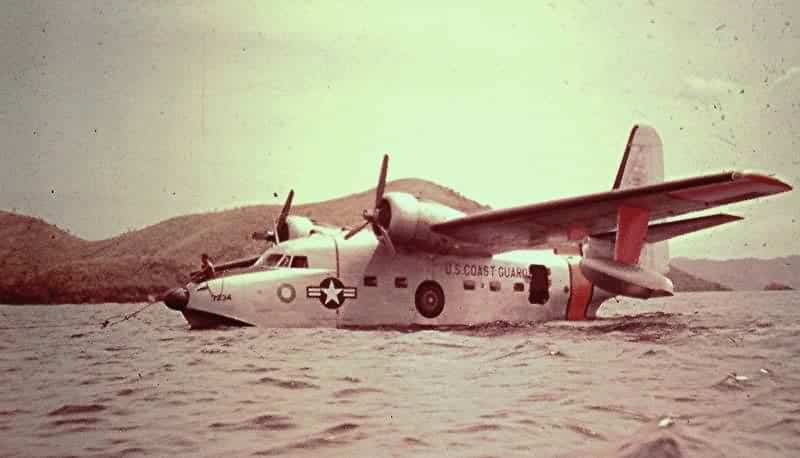
LORSTA Catanduanes: The island of Catanduanes lies 230 miles east-southeast of Sangley Point. The hilly terrain was unsuitable for an aircraft runway. The LORSTA, known simply as Cat, was situated at the north end of the island with a bay immediately to the west that was adequate for UF-2G water operations as long as the wind and sea conditions were favorable. The aircraft tied up at a buoy and supplies were unloaded by small boat and transported to the boat dock. The bay was semi-exposed to the sea and when the incoming swells made the bay dangerous, landings were made at the south end of the bay. This was separated from the main bay by an island and coral reefs. The aircraft, when using the south bay had to be unloaded at anchor and supplies transported by vehicle to the LORSTA.
LORSTA Naulo Point: Naulo Point LORSTA was in the midst of a coconut plantation on the West Coast of Luzon five miles south of Santa Cruz. Naulo had a grass and dirt 3000 foot airstrip with tall palm trees at each end that the Pilipino land owners refused to cut down. When wet the runway limits were defined on each side by heavy mud and an errant taxi turn would result in the aircraft being bogged down requiring a combination of truck and caribou power to regain the runway. Caribou (water buffalo), the beast of burden in the Philippines, grazed on the runway and had to be herded off prior to landing. Usually, this was accomplished by the combined effort of station personnel and the distinct loud propeller noise generated by a UF-2G making a low pass. The impact of a main gear coming in contact with a freshly deposited pile of Caribou dung produced the expected results.
LORSTA Talampulan: Talampulan was one of the islands forming the Calamian group which lie 200 miles southwest of Sangley Point between the large islands of Mindaro and Palawan. The island was a long and narrow jungle covered hill without a landing strip. Landings were made adjacent to the island and heavy ocean swells frequently made it a hazardous operation. A slot between two islands to the east offered a more protected landing but required a long wet taxi through the swells to the mooring buoy. With windows and hatches secured for water tightness, this prolonged taxi in the tropics was far from popular. A truly beautiful island, Talampulan was a source of giant clamshells that were sought after by the military personnel throughout the Pacific. Many a clam shell was hauled out.
LORSTA Tarumpitao: Tarumpitao was located on the western shore of Palawan Island, 375 miles southwest of Sangley Point. The station was a collection of Quonset huts and a 3000 foot grass runway set in a clearing in the middle of a dense jungle. The strip had been built by Coast Guard civil engineers and there was little doubt in crewmembers minds that the person who designed it hated aviators. The runway ran into the jungle perpendicular to the shoreline. A tall hill was at the other end. Of further concern was the narrow clearance between the runway and the trees and the prevailing wind was across the runway at a ninety degree angle. During the rainy season, the runway was covered with standing water. Braking action was nil and reverse thrust was used to stop the airplane. The native population, unlike at the other LORSTAs, were Morros and were Muslim. There was friction between the Morros and Christians but for some reason that did not apply to the Coast Guardsmen. A discarded Quonset had been donated by station personnel for use as a school house. There was a standing invitation to the locals to come on board the station and watch the movies. The invitation was eagerly accepted.
The entire Coast Guard Philippine operation was turned over to the Philippine Government in 1971 and the Coast Guard air station was closed.
And so it was back then – there are some among us that look back fondly and sometimes wistfully – forever grateful – and realize it will never be again!
A special thanks to Captain Gus Shrode and Captain Carl Swickley. Both flew out of Sangley and related their story.